Overseas News on Civil Engineering IT
|
|
This section focuses on a unique overseas website concerned with civil engineering IT. Featured below is the site of "50th Anniversary of the Interstate Highway System," which is created and administrated by Federal Highway Administration (FHWA) to commemorate the 50th year (2006) since the construction of the Interstate Highway was initiated.
The Background of the Concept and the Process of Its Realization Interstate Highway System (IHS) is officially named as the Dwight D. Eisenhower System of Interstate and Defense Highways. In response to signing of the Federal-Aid Highway Act of 1956 by President Dwight D. Eisenhower, the project, the Greatest Public Works Project in History according to the website, started moving. Originally, highways in the United States had basically been planned and constructed in each state. With this as a background, the necessity gradually increased to build a highway network that links different states throughout the whole nation, which motivated to initiate the project. The concept of an Interstate system was first described in a 1939 report to Congress called "Toll Roads and Free Roads." President Eisenhower played a great role in promoting the concept in the process of embodying it. It can be said that the network's name, which includes the word "Defense," directly reflects the experience of the World War II as well as the influence of the Cold War between the East and the West. However, according to the web site, main purposes of forming the network are based largely on civilian needs including economic development, improved highway safety, and congestion relief. The military value of the Interstate System and its use in evacuations are positioned only as partial needs. The story behind the creation of IHS and its positioning are explained in the corners of History and Interstate Myths on the web site. Effective Use of Motion Pictures and Illustrations, Devised to Stimulate Viewers' Interest from Unique Perspectives On the top page of the web site is a congratulatory address by President George W. Bush, below which is a message from J. Richard Capka, Administrator of FHWA with links to the video images of his interview. |
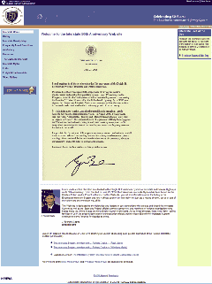
  Top page: 50th Anniversary of the Interstate Highway System ((c)Federal
Highway Administration) Top page: 50th Anniversary of the Interstate Highway System ((c)Federal
Highway Administration)(Reprinted by courtesy of FHWA) |
|
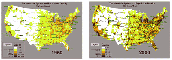
| Interstate Density Map shows the progression of the Interstate System decade
by decade along with the changing population density in a visual representation.
It depicts how the network was essentially complete by the 1980's, while
population has been increasing dramatically through 50 years. Entitled "Historic American Roads," Art Gallery provides commentary with illustrations. It presents epoch-making events from 1808 through 1945 in order. On the other hand, "Memories" exhibits a collection of personal stories about IHS told by various people concerned. Furthermore, motion pictures have frequently been utilized as a supporting tool for publicity work. To demonstrate them, the Video Gallery puts some of the past pictures produced by the Bureau of Public Roads on view to the public, e.g. "Rhythm of the Road (1937)," "The Road to Happiness (1924)," and "The Road to Prosperity (1961)" ("Rhythm of the Road" is a British film as an exception). In addition, "FAQ" provides answers to the basic questions about IHS. With it as basic knowledge, "Interstate Myths" seems to be designed to have IHS understood correctly and fascinate the viewers by correcting and complementing the prevalent stories about it that are mistaken or exaggerated to some extent. "For Brainiacs" is a page designed specifically for kids. It is assumed to serve as a resource for answers to questions or school homework reports. "Interstate Fact of the Day" corner displays handy pieces of information about IHS on day-to-day basis, explaining such information that satisfies curiosity for varied knowledge from a serious perspective. The pieces of information shown in the past since its starting can also be viewed. |
||

 Transition of the Interstate System and Population Density, comparison
between 1950 and 2000.
Transition of the Interstate System and Population Density, comparison
between 1950 and 2000.<From "Interstate Density Map: Web site of FHWA," reprinted by courtesy of FHWA>
This article is written based on the above web site under the permission of FHWA.


