Program Overview Program Overview
 |
|
VR-Studio(R) is an advanced VR system made with the latest architecture.
New features include support of large scale project handling a lot of terrain
data, new CAD style user-interface utilizing diagrams and objects, multi-user
editing, improved performance based on multi threading and modified section
functions.
|
|
|
|
< Ver.1.02.00 (released on September 3rd, 2010) updated items >
- Improved intersection editor user interface
- Additions of break lines (contours)
- Mass positioning and fill
- Addition of new road type (walls, hedges, fences)
< Ver.1.01.00 (released on 24th December 2009) Updated contents >
- Model LOD (level of Detail)
- Enhanced support for 3D mouse and improved frame rate
- Rapid filter command
- Aerial photography editing function and image grid definition function
- Copies available for all resources
- Cutting/Banking calculation with background processing
- Improved vertical cross section alignment editing screen
|
|
 Large and flexible terrain and space Large and flexible terrain and space
- Terrain LOD(Load of Details)
- Flexible creation of terrain
- Easy extension of terrain data
Multi-reality (Extended "Before-After")
- Allowing quick switch of multiple plans including 3D road model
Multi-user editing and discussion
- Single user / Team user version available
- Allows multiple users to edit different parts of a project at the same
time
- Lock based system
- Road split into multiple sections, editing functions
- Full history of change
Enabling advanced traffic simulation
- More configurable parameters for drivers
- Improved behaviour of drivers
- Generation of traffic for each lane
Dramatic improvement in performance (on Multi-processor Multi-core CPU)
- Dramatic reduction of VR data creation time
- Improvement in traffic simulation abilities
|
 |
|
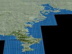 |
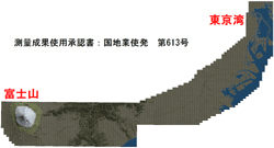
 Creation of large space Creation of large space |
|
From Miura Peninsula to Tokyo |
 |
|
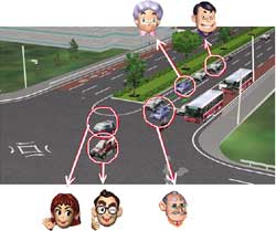 |
| Team work computing(image) |
|
Parameter settings of drivers |
|
|
Program Function and Features
|
|
 Large scale data Large scale data
SinceVR-Studio does not have a limit on the scale of data, you can create
large scale data of over 100km. It allows you to design long-driving roads
and create wide areas and traffic networks. If you would like to enhance
the area, you can add terrain area, it allows you to reuse the data you
have created and enables efficient work. We have developed functions of
terrain creation and terrain processing. VR-Studio(R) has 50m mesh DEM
data. (use of survey data is approved by Geographical Survey Institute)
Performance
VR-Studio can process in parallel by adapting multi core CPU and multi
CPU. At the time of dividing triangles and generating LOD data, VR-Studio
does parallel processing. at the time of triangle division of terrain data
and generation of LOD data.
Terrain LOD function
Since VR-Studio has adapted LOD (Level of Detail) technology, it can display
terrains of wide area speedily. Surface of the terrain is basically expressed
by the triangle. If you draw detailed terrain in VR space at the point
distant from the view, triangle of a few pixels or triangle of smaller
than one pixel might be drawn. Since the triangle has being drawn at the
same place, the process will be useless. With LOD, VR-Studio draws a visible
triangle on screen in a certain size, and estimates the size of the triangle
to reduce the amount of processing and draws a triangle combined from multiple
triangles based on the size of triangles.
This technology enables better display performance even when handling a
large scale terrain because the number of triangles does not increase.
In addition, for a reduction in the processing time and updating the screen
each time. Data is saved of the combined triangle in advance, and selects
and displays the appropriate combined data while processing drawing.
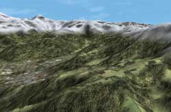
Terrain Procedural Texturing
This technology processes images to paste on 3D objects. VR-Studio selects
image from height and slope and alters the image to fit to the shape. It
enables realistic terrain expression from DEM data or TIN data
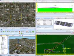
User interface
- Multi modal screen
In VR-Studio, you can check the 3D view and edit at the same time. You
can do this work by opening 2 screens at the same time. For example, you
can check and edit one element from multi point of view. Using multi monitors
makes the interface easier to operate. FORUM8 have developed it in a concept
of adjusting VR-Studio interface to users' work environment by offering
flexible user interface.
- Undo/Redo
VR-Studio has strong undo/redo functions. This allows you to go back to
the previous status or operate again by using undo/redo buttons for all
editing operations. Since history of the edit is stored, VR-Studio does
not have "confirm" and "cancel" button on each edit
screen.
- Data check
At the time of the creation process, input data may become temporarily
invalid, VR-Studio does not require valid data input. When invalid data
is input, the system does not go to the next process, however, data is
saved and you can continue the inputting of data. In addition, you can
see the location of the parameters where invalid data is input in order
to make data correction easy with the data verification tool.
- Layer
VR-Studio has a layer function and can display each element of the data
by layer.
Creating VR space
VR-Studio allows you to create VR space that consists mainly of outer building
space and makes terrain and roads easily. In addition, it allows creating
lakes, flight routes, background, rivers and pipes and the setting of 3D
models and trees.
Creating roads
By setting the horizontal alignment, longitudinal slope, cross slope by
an element of cross section the 3D model of a road is generated automatically.
You can easily set, move, add and delete transition points with mouse clicking,
you can also enter the exact figures for the actual road design representation.
After you have created road alignment, you can define the cross slope by
cross section. Creation of the road alignment is finished by making the
necessary cross section first and applying it to road alignment.
Measuring point
Elements placed on the road, such as a cross-section, bridges and tunnels
are set according to the distance from the starting point. You can add
a station point and set the elements based on the distance from the station
point. Station point should be set based on the distance from the other
elements (including the start point). If you change the position of the
station point, the element belonging to the station point is updated. With
this feature, after setting station points in along the road, you can easily
correct the positioning of the elements after editing and road alignments.
Cross section and cross section parts
One cross section comprises of combinations of multiple parts. The parts
define the width of the parts of a road. For example, vehicle road, pedestrian
road curve and division can be made as a part.
Modifier
While you can change the gradient for the width of the road by using a
cross-section, you can change the gradient for the width of part of the
road at any point. It is possible to update only the width in that position.
If you set a modifier element, you can set the following.
- Insert, delete and replace of the cross section parts.
- Change parameters of cuttings and banks
- Add markings
- Change start point in cross section
Transition of cross section slopes can be modified with cross section.
You can update the width of the fixed point by setting modifier element.
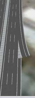
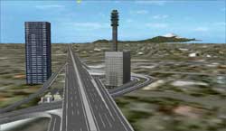
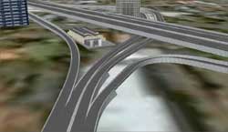
Traffic network
VR-Studio has function to create whole traffic network. It allows you to
make road structure below easily and efficiently.
|
Ramp road |
: |
Set the point of ramp connection on main road and allows drag-and drop
road connection. |
|
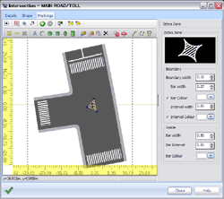
intersection |
: |
When you execute intersection generation after setting road, basic shape
of the intersection is set automatically. VR-Studio offers functions for
modifying the shape of intersection by editing screen and creating marking. |
Bridges and tunnels are automatically generated by defining cross section
of road bridge beam or tunnel wall and setting bridge and traffic space
on road alignment. To lengthen the traffic network, you can connect independent
to the end of the road.
Multiuser editing
VR-Studio allows the editing of one project by multi users with multi-user
editing function. Users can share the data with the source management server,
and manage store and synchronize. When you work, get the latest status
of the data from the management server, and you can update the data on
the server after editing by the local machine. When multiple users work
simultaneously, the element is locked to edit and one element can be edited
by only one user. After editing is over and server data is updated, the
lock will be released and other users can edit the data. Work by this procedure
allows simultaneous editing of the independent elements by multiple users.
It leads to improved efficiency in working with large-scale data.
In addition, complete editing history is recorded by using the management
server, it allows you to return to incorrect data on the previous status
and edit.
Multi reality
This function allows comparing of multiple plans at the time of presentation
and assessment or comparing before and after the construction of the project
for improvement. All of the models, or part of the models can be switched
to another condition-reality. It allows examining multiple marking plans
of intersections, comparing road alignments and comparing house developments
and other plans
 |
|
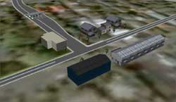 |
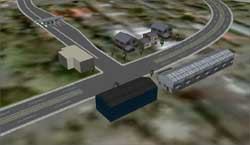
 Multi reality Switching 2 lane road to 1 lane road (sample data) Multi reality Switching 2 lane road to 1 lane road (sample data) |
Sample data
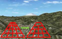
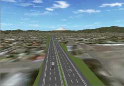
VR-Studio has sample data. The shape of the terrain data is not rectangular.
The length of the highway-like road is 70 km. If you move to the favorite
point "Mt. Fuji", you can see the sight from the top of the Mt.
Fuji. Move to camera position "Projectview", you can see the
interchange. If you look at ramps at the interchange, you will find that
the road is divided or connected with the large angle and you can see the
smooth connection of roads at the junctions and sections.
Move to camera position "Townup", here is a 3-junction intersection
to the sliproad to the highway. VR-Studio allows the changing of road structures
including intersections. When you drive the road, you can drive a car in
any direction or alongside the road as well as in any of the existing lanes
within the sample data.
 |
|
 |
| 70km-length long driving road and space, High accuracy connection of junction
(sample data) |
Future Development
- Traffic simulation :
We are developing a traffic simulation function of the road network. We
are planning to implement a signal control, complicated drivers behavior
and detailed settings of the amount of traffic and the driving pattern.
- Data link :
Link to/from various design software and analysis programs planned.
We are planning to enhance the standard format of 3D models and standard
file formats of road design.
- Railroad :
Adapting a special curve form of the railway alignment and the function
of railway crossing as well as an intersection.
|
|