Introduction Introduction
- The New version of VR-Studio is scheduled for release at the end of 2010
and development work is in progress - this new version will support traffic
flow functions. Prior to the release, the following updates have been added:
Intersection Editor
- The user interface of the intersection editor was greatly improved making
it much easier to use. Specifically, the outline directory tree and the
tables can now be edited. The following features were revised in the intersection
generation function.
- Intersections can now be generated in the cross section vertical curve
view, just as in the 2D plan view.
- Since the intersection can now be automatically generated selectively,
it is no longer necessary to create intersections at every potential intersection
position.
- Duplicate intersections are now ignored.
- Gutters can now be generated along roads at intersections.
- Leg lengths can now be edited as a part of the intersection generation
process.
- Parameters of road cuttings and banks can now be edited at the intersection.
- Trees and other models can now be assigned to the intersection as roadside
objects.
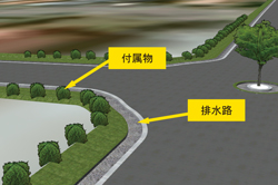 |
 Gutters and roadside objects at an intersection Gutters and roadside objects at an intersection |
Additions of terrain contours
- Break lines (contours) can now be added while editing the terrain area
points. The break lines remain in the surface triangulation that controls
the terrain. When the break lines are not used, triangulation is automatically
done from the point cloud data and the terrain is generated. However, the
triangle edges cannot be defined, because they are automatically generated.
Furthermore, if the break lines are defined, they remain as the edges of
the triangle.
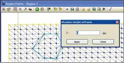 |
| Defining contours |
Mass positioning and fill
- Areas can be filled with objects, for example, forests can be generated by placing trees. This is done by randomly selecting linear intervals and offset of objects in roadside object function. These objects can be placed along all roads and flight paths.
-
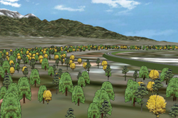 |
| Forest generated along the flight path |
Enhanced editing chart
- The editing of planar direction change chart for roads have been improved and it now includes parameters for the beginning and the ending of a curve radius, radius of a circle, arc length and the curve type at the beginning and the ending of the road. Tables of parameters can now be pasted onto an Excel spreadsheet.
Model arrangement
- Following modifications were made as well as improving the general operations
- Models placed using "Place on ground" function remains attached to the
ground (i.e. it will not float in air nor be buried underground) when there
is a change in the terrain height due to editing or due to the difference
in the terrain in various "realities".
- Models can be copied and pasted using Ctrl and C or V and defining the offset.
Other functions
- Addition of new road type
"Other paths" is now included in "Road types". As a
result, walls, hedges, and fences can be efficiently made. The default
settings of this function can be changed in the "Project options"
in "Tool" menu.
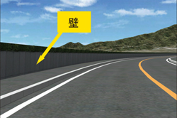 |
| Wall along the road side |
Road type colors
To distinguish various types of roads in the 2D plan view, roads are displayed in different colors based on the road types. For instance, road is black as a default, and railroads are drawn in purple. The default color settings can be changed in "Color setting window" in "VR-Studio option".
Improvement in 3D mouse operation
3D mouse will be automatically effective in 3D view, plan view, CAD view, satellite view, and new project wizard and edit of the intersection.
Quick filter cancellation
When selection is enabled, filters can be cancelled by clicking on the quick search field
Display of individual satellite image grids
Now controllable in the satellite imagery editor
Data conversion in UC-win/Road
- VR-Studio was originally developed with a view to develop a new software program which eliminates limitations in our original VR software program, UC-win/Road. However, due to the difference in software configuration between these two programs, data files cannot be shared between these programs. However, a plug-in is being developed so that UC-win/Road files can be converted to a file that is compatible with VR-Studio.
In the main feature of this plug-in, UC-win/Road data that is running on UC-win/Road can be transferred to the VR-Studio, which also needs to be running simultaneously, directly on RAM. However, data conversion is still necessary for some data, which has massively different configuration (refer to table 1 for what can and cannot be directly transferred).
| Object types |
Conversion availability |
| Textures |
- |
| 3D models |
- |
| Terrain/Terrain Patch |
Available |
| Road section segments |
Available |
| Road section |
Available |
| Road alignment/ vertical curve |
- |
| Ramps |
Available |
| 2D Trees |
- |
| Road Model |
- |
| Roadside Vegetation |
- |
| Aerial Photographies |
Available |
| Road Signs |
- |
| Camera Positions |
- |
| Sceneries |
- |
- Regarding the conversion process of road section
In VR-Studio, road sections are divided into multiple parts, unlike in UC-win/Road. Before the data transfer from UC-win/Road to VR-Studio is carried out, the road sections are split appropriately and segments and the road section settings are transferred. Figure 1 shows how the road sections are divided. In some cases, segments with same geometries are generated, thus, VR-Studio compares the geometries of each segment and minimizes the number of segments for output.
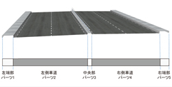 |
| Figure 1: Ways in which road sections are divided |
- Processing of ramp
VR-Studio supports two types of ramp connections. There will be the same number of lanes on the slip ramp as the number of lanes that is added to the main line just before the slip ramp. For example, if there are 2 additional lanes on the main line just before the slip ramp, there will be 2 lanes on the slip ramp, which diverges from the main line.
UC-win/Road only supports Split ramps. Split ramps are created by assigning section changes and transitions on a road.
When data is being sent to VR-Studio, the road must be assigned as a Split
ramp, and the geometry must be similar to that in UC-win/Road. When the
ramp is connected to the main line in VR-Studio, the horizontal alignment
of the lamp is automatically corrected. Therefore, the alignment in VR-Studio
may differ from that in UC-win/Road.
Functions under development
- Traffic simulation
The next version of VR-Studio is under development, in which traffic can be simulated on the roads. Traffic volume by road sections, traffic control, defining road signs and traffic lights, changing the ratio of vehicles making right turn, left turn and going straight and many more simulations can be executed.
Compatibility for microsimulations and OpenMicroSim
VR-Studio will be able to carry out traffic microsimulation. Each vehicle will have its own realistic vehicle dynamics models and driving behavior patterns based on the road geometries, and the traffic simulation will consider the physical restrictions of the network and the vehicles. The eventual simulation of the traffic flow is enabled using vehicle dynamics model with the algorithms of lane-keeping, acceleration and braking, which utilizes steering and pedal operation. Moreover, traffic simulation data can be exported using OpenMicroSim data format (http://www.openmicrosim.org).
Script and simulation
Manipulation of VR space and presentation function will be enhanced. We are planning to make camera view operation, switching to and from multi-reality and the simulation of driving and flight paths easier. And new user Interface for presentation functions will be developed. Moreover, to reproduce the control of the VR environment which was created beforehand, we are going to develop the script function as a one of the tools for presentation.
|