Program overview Program overview
 |
|
12d allows fast production in a wide variety of projects including mapping,
site layouts, road, rail and highway design, residential & land developments,
and environmental impact studies.
Developed by : 12d Solutions Pty Ltd ( http://www.12d.com/ ) |
|
| Joint marketing agreement |
 12d UK Ltd. and FORUM 8 have reached a joint marketing agreement (April. 20, 2010) 12d UK Ltd. and FORUM 8 have reached a joint marketing agreement (April. 20, 2010)
- FORUM 8 is aiming for clollaborative marketing in Europe after the development of UC-win/Road for 12D Model.
FORUM 8 is aiming to provide its state of the art Virtual Reality technology to 12d customers, while, in turn, provide 12d's modeling and designing technology to UC-win/Road customers.
>> 12d UK Ltd / 12d Solutions http://www.12d.com/
|
 Related Information Related Information |
Detailed Product Information
New Product Introduction
FORUM8 was introduced on Ken Pllats, Construction IT portal site of Nikkei Business Publications. (Japanese)
|
|
Page Top  |
|
Program function and feature
|
|
 Program feature Program feature
- Up to 500 million coordinate points
- Supports sounding data
- Allows editing TXT files and importing CSV coordinate points
- Available to import or export various files at the same level as GIS software
- Volume calculations are calculated at ground surface by using PAD or GROUND.
- Supports 3D view function, texture mapping, automatic flight path display.
- Plain view, longitudinal section view and cross section view can be made at once by using drawings associativety and Open-GL function.
- Module can be selected purchased separately depending on the budget
- English version (Some manuals were translated into Japanese) Open price
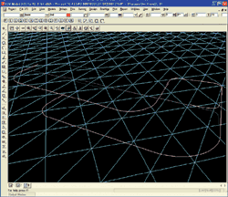
Base product‐DTM Builder
The 12d Model base product contains all the options necessary to produce
a digital terrain model (DTM or TIN), including fast triangulation, contouring
and sectioning routines.
The 12d Model base product was written from the ground up for the civil and surveying market. Work flow follows traditional engineering ideas.
The base includes the string types 2d, 3d, 4d, interface, pipe, text, alignment and super to allow accurate civil engineering and survey modeling.
 |
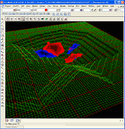
 Base product screen image Base product screen image |
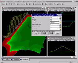
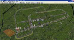
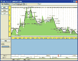
Volumetrics, Tin Analysis & Earthworks
This module is used for calculating earthworks volumes within a user defined
polygon. Volumes can be calculated between a triangulated model and a fixed
height or between two triangulated models. Reports of cut and fill areas
and volumes are given. on a section by section basis. Then, depth volumes
can be colour coded for validation and plots.
using the end area method, a height range basis by
The triangulation analysis module has options to calculate surface area, depth contours (isopachs), the intersection of triangulations.Land use studies, landscaping and other civil design tasks can benefit from this comprehensive suite of triangulation analysis options.
 |
|
 |
| Volumetrics image |
|
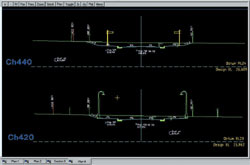
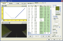
Cross sections image |
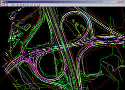
Detailed Alignment design
The module carries out full range civil design work. It allows to design
from basic roads to multi lane highways with major intersections and exits.
The Detailed Alignment Design module provides design capability and string
modifier operations to allow interactive design of the most complex civil
situations.
Module functions
- Modifying design cross-fall between chainages
- Modifying road width between chainages
- Modifying string height between chainages
- Projecting the cross-fall between two existing strings
- Widening out to an existing string
- Curb return function
- Creating cross sections at user specified chainages
- Modifying the height and/or offset of the hinge string
|
|
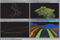
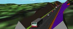
 UC-win/Road Plug-in option UC-win/Road Plug-in option
<Related article> UC-win/Road for 12D Model (Up and Coming New Year special issue)
(1) Data link from UC-win/Road to 12d Model
 Link of terrain data Link of terrain data
Terrain data of UC-win/Road can be converted and exported to Tin file of
12d Ascii File Format.
Link of road data
Data is divided into horizontal alignment data, vertical cross section data and cross section data. In 12d Model, horizontal alignment data and vertical cross section data are regarded as input data, while cross section data is regarded as result data. Therefore, horizontal alignment data and the cross section data is converted and exported to 12d Model. In addition, users can define the conversion of the the UC-win/Road 12d to the Alignment of the Super Alignment of the Ascii File Format.
 |
|
 |
| UC-win/Road |
|
Imported UC-win/Road
data to 12d Model |
(2) 12d Data link from 12d Model to UC-win/Road
- Link of terrain data
12d Model regards terrain data as TIN data structure and the range of the
terrain is not limited. UC-win/Road regards terrain data as grid data structure.
The size of the cell changes according to the size of the range of the
terrain. To express more detailed terrain data, UC-win/Road can generate
terrain patch. In addition, TIN model of 12d Model terrain can be converted
to UC-win/Road terrain data or terrain patch data.
Link of road data
There are two ways: Alignment and Super Alignment in 12d. Users can define
the Alignment or the Super Alignment when converting the road data.
 |
|
 |
| 3 Link of terrain data and road data |
|
Link of vertical cross section data |
 |
|
 |
| Link of cross section data |
|
Expression by UC-win/Road |
|
|
|