|
|
 |
Geotechnical Analysis |
 |
|
|
|
|
Advanced analysis software which can respond to a performance examination-by-reference
design
|
|
|
|
|
|
|
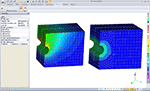
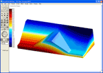
GeoFEAS3D is '3D Geotechnical Finite element Elasto-plastic Analysis Software'.
It is the software product for 3D stress-deformation analysis of soil under
static conditions.
|
 |
|
|
|
|
|
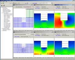
GeoFEAS2D from 'Geotechnical Finite element Elastoplastic Analysis Software'
is the software product for stress-deformation analysis of soil under static
conditions. This software conducts the powerful elasto-plastic finite element
analysis in many engineering fields such as slope stability analysis, earth
retaining works excavation analysis, tunnel design, etc. This product consists
of three programs, (1) preprocessor, (2) processor, and (3) postprocessor.
Finite element analysis conditions are created in preprocessor as CAD software,
elasto-plastic problems are analyzed in processor, and analysis results
are processed for visualization in postprocessor.
Japanese/English versions |
 |
|
|
|
|
|
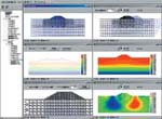
This program is to analyze dynamic land transformation using finite element
method (FEM). Taking into consideration the method of elastic theory based
on effective stress, excessive pore water pressure which occurs during
earthquakes and the declining of stiffness, it is possible to calculate
land transformation by the hour. This program can be applied to investigating
the stability of earth structures (banks or raised mounds), the lift of
underground structures, and the dynamic interrelation between an earthquake
and structures. Another program with function to decide parameters in liquefaction
is attached. It allows you to input in a CAD style making easy creation
possible. It also accepts reading from SXF files. The analytic core of
this program makes use of the land analysis program by Prof. Ugai and his
research laboratory at Gunma University who enjoys advanced analytic theory
and brilliant achievements. It is jointly developed by our company which
is engaged in the development of the prepost part and the university.
Japanese/English versions |
 |
|
|
|
|
|
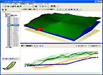
At present it is common to analyze slope stability with two-dimensional
plain surface in mind, but this program will enable you to make stability
analysis reproducing real land shapes and sliding surface in three dimensions.
Three-dimensional land shapes are designed to be displayed relatively with
ease by entering plenty of cross-sectional drawings in a two-dimensional
method. In the process of countermeasure work it is possible to draw up
a plan of piling using three-dimensional deterrent force, with consideration
that putting in piles can be easily put into image in a two-dimensional
way. Moreover, considering that current standards about a piling plan are
intended for two-dimensional deterrent force, this program is designed
so that you can make a plan of piling by means of two-dimensional deterrent
force as well.The analytic core of this program makes use of the land analysis
program by Prof. Ukai and his research laboratory at Gunma University who
has reputation for advanced analytic theory and brilliant achievements.
It is jointly developed by our company which is engaged in the development
of the prepost part and the university. |
 |
|
|
|
|
|
Saturated/unsaturated seepage analysis program using Finite Element Method
(FEM) is based on the analysis solver produced by the Prof. Ugai laboratory
(Department of engineering, Gunma university). This product has been developed
by customizing VisualFEA as pre and post parts. It provides easy ways to
generate two and three dimensional (2D and 3D) complicated shaped geological
boundary models, and several functions such as regular meshing, auto-meshing
and re-meshing by setting types and dimensions of elements. Stationary
and transient analysis can be conducted in 2D vertical, 2D axisymmetric,
horizontally 2D and 3D models using several boundary conditions. |
 |
|