Support Topics
Support topics / UC-win/Road 保守・サポートサービス関連情報
CityDesignTool Vol.1 (7-times series) PovrayToMax

This article is written by Kobayashi, Associate Professor of Arizona State University to introduce City Design tool, which was released by FORUM8.
I am going to develop tools for the seamless data generation and exchange between VR software package UC-win/Road by FORUM8 and other 3D CG packages. Source code of the tool introduced here is open to public, however since we are not offering support services, we cannot take responsibility for issues such as bugs. Thank you in advance for your understanding.
I would like to hear from people in the architectural and civil engineering industries on your needs for concise tools suited for your system.

Why city generation tool now?
Let me introduce the background of the development of the tool. Originally I have been interested in generation process of the 3 dimensional city model and have been studying how I can reconstruct the existing cities as digital data easily. During my PhD course, I developed a tool for the generation of city models from aerial photos, using technology of image recognition as well as neural networks, artificial intelligence and machine learning.
However I am intentionally away from the development of design tool using artificial intelligence. My theory is "performance of the design tool depends on how high-impact design products can be produced with the tool. Even when I develop new technologies, the development activity of the design tool cannot be highly valued as "research" if I cannot demonstrate something exceeding what people are accustomed to by watching Hollywood movies. . For example, there is a tool called CityEngine developed by Procedural company. I believe why this tool draws attention is because of the tool's ability to demonstrate the impact of its city model, which is unbelievably precise and sophisticated on top of its ability to be produced automatically.
What I am aiming to achieve with CityDesign is the tool development which demonstrate the impact by a technology engineer. The keyword is "speed". I'm interested in a tool development: "Using the new technology which realizes dramatic time reduction and cost for something which can be possible with existing technology". It is rather a development of a framework which simplifies the design process while maintaining flexibility than a development of new technology. I am aiming at acceleration, not to the extent that "quick production allows the cost reduction per unit and the offering of products at cheaper prices", but to the extent that possible to meet the request of "completion by tomorrow with the 3-10 times the cost".

PovrayToMax
Firstly, I would like to introduce the tool, PovrayToMax. It can automatically generate 3 dimensional data from 3D model files, produced and saved out of UC-win/Road.
Below are how to use PovrayToMax.

  1. Choose [Run MaxScript] button from [MaxScript] roll out block in [Utility] tag in 3ds Max and execute "PovrayToMax.ms" file.
  2. Choose [Pov-ray Importer] from among pull-down menu below the button, and UI is loaded
  3. Choose [Get Mesh Povray] button to generate Povray file of roads and intersections, or choose [Get Mesh2 Povray] button to generate 3D data of terrain and other data, and specify Povray file.
  4. Choose [Union Object] button to specify n Metafile: Roads.inc, Intersections.inc or other data.

Make sure that run [Union Object] button every time after loading the single data. You do not have to load unnecessary road data in advance. However since a metafile generate components as instances from assets, they are not registered as assets if you have not loaded beforehand. I recommend you to generate components one by one instead of loading the data at once.
Its application includes data edit to output by 3D from UC-win/Road and 
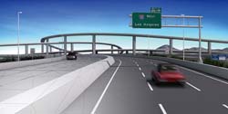
creation of still image with advanced rendering. Figure 1 shows the data, created by UC-win/Road and rendered by 3ds Max using special effects such as motion blur. Figure 2 shows the physical architectural model, a production of 3D printer from the data, which is created by UC-win/Road VR and exported to 3ds Max.

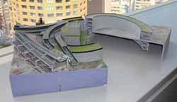
Figure 1 Data, created by UC-win/Road and rendered by 3ds Max using special effects such as motion blur Figure 2 Physical model, a production of 3D printer from the data, which is created by win/Road VR and exported to 3ds Max

Try MaxScript!
In 3ds Max, a language called MaxScritpt is available, which allows you to develop your own tool concisely. Many programmers seem to imagine "script", a simple language used to write code easily. Of course I agree with the technical definition of script which can perform functions that are hard-coded, while I have a different opinion. In fact, the script of the latest CG package" is a very strong "Thinking Tool". I am evaluating it because we can edit basic vertex, edge and face in the mesh with flexibility, rather than using a complicated geometry operation function. The tool is often used in creating actual Hollywood movies.
Some readers might have studied program in computer science in 1980s or early 1990s. At that time, written code, as is in LISP and Prolog was continuously stored in memory, and was able to perform the update of data and function was done interactively and flexibly. Even the simple list operation such as CAR and CDR can solve many issues of artificial intelligence. I am very sorry that programming skills has become the simplest issue of memory how many functions do they know, such as MFC (Microsoft Foundation Class) and OpenGL.
Let's get back to the theme, MaxScript can manipulate the 3D data like we did with list manipulation of MaxScript. You can realize choosing the meshes which meets the condition with the cord of 2-3 lines, and creating another geometry data in high-end CGpackage. I would like you to experience the reduction of time and effort, or joy of the programming with mathematical way of thinking in 1980s.

Conclusion
I would like to introduce following tools.

  1. Image To Terrain Tool:
    Tool for the generation of terrain data to fit UC-win/Road from image data
  2. Animated Character Tool:
    Tool for the conversion of animation character model created in 3ds Max to PK3 data read by UC-win/Road directly
  3. Satellite Image Tool:
    Tool for the extraction of aerial photography from Google Earth Pro, in which terrain data match coordinates
  4. Image To City Tool:
    Tool for the generation of 3D city data including building from road lines, zoning and terrain data.
  5. Facade Generation Tool:
    Tool for the generation of image data of building facades with drag-and-drop operation
  6. Baked Texture Tool:
    Tool for the automatic generation of texture, on which is shades and GI, global illumination is baked

Please look forward to the next issue

BACK INDEX
(Up&Coming 2011 Early Spring Issue)
back
Up&Coming

FORUM8