New Products
UC-win/Road Ver.12
3 dimensional real-time VR software package

●Price Ultimate:$18,000(SS:$2,700) Driving Sim:$12,800(SS:$1,920)
Advanced:$9,700(SS:$1,455) Standard: $6,300 (SS:$9,450)
●Released December 2016
UC-win simulation
 UC-win/Road Ver.12 64bit version
Most of the currently released package software is developed for 64 bit OS and used as 64 bit application (hereinafter referred to as 64 bit App). UC-win/Road will also be reborn as 64 bit App.

Generally, on Windows 64 bit OS, WOW64 (Windows on Windows64) that plays the role of virtual 32 bit OS is activated in 64 bit address space and operated in 32 bit address space in order to operate 32 bit App directly. Memory usage of 32 bit App is limited to 4GB.

This 64 bit support utilizes full PC resources. Over 4GB memory is available, and speed is expected to be increased because there is no intermediate intervention like WOW64.

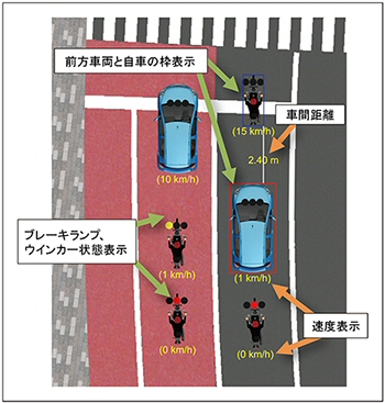
Features enhanced by UC-win/Road
Various benefits can be expected by 64-bit conversion. Typical examples are shown below.

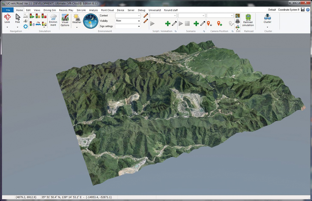
1. Expansion of terrain space and improvement of resolving performance
Simulation of long distance roads on a vast terrain can be performed by expansion of terrain mesh size. For example, previous 20km x 20km terrain space with the standard Japan map can be expanded to 400km x 200km. This expansion and finer mesh settings will describe more realistic terrain.

Fig. 1 Expansion of terrain space

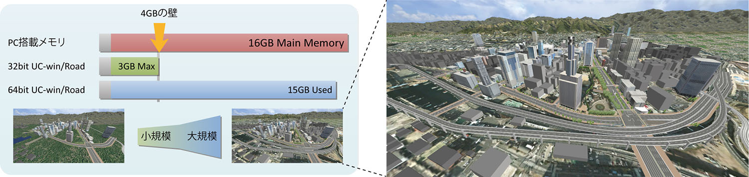
2. Expansion of the number of arranged models
Many model geometry information can also be arranged without worrying about the 4GB limit. Especially, it is effective when to simulate urban space, and buildings can be displayed smoothly though they are modeled individually.

3. High qualified texture
The limit amount of available textures such as ground surface, road surface, and model is greatly increased, and multihued description will be possible. For example, landscape can be created naturally and a sense of immersion will be improved by expanding the spacing of road texture repeating pattern, and increasing sections and altering road texture.

4. Visualization of analysis result
A lot of memory is required to visualize analysis results including animation steps such as tsunami, flooding, wind, or noise. It will be possible to perform a long-haul visualization simulation that was difficult until now.

Future enhancements associated with 64bit support
We will introduce plug-ins that will be enhanced with 64bit support.

Spatial numerical accuracy
When describing value on a computer, the accuracy depends on the type of register that stores real number. There are a single precision and a double precision. The former has 7-digit accuracy and consumes 4 bites per data, and the latter has 15-digit accuracy and consumes double capacity. UC-win/Road uses the single precision to gives priority to memory usage efficiency, but it will replaced with the double precision because memory limit will be virtually lost by 64 bit support. This improves the reliability of mutual conversion between latitude or longitude and orthogonal coordinates. In a driving simulation, smooth change in direction can be described by using the double precision for vector in camera direction and calculation of precise panning, tilting, and rolling when calculating the direction of travel from subtle steering operation.

Point cloud modeling plug-in
An abolishment of the limit of the number of point cloud up to 70 million makes it possible to load 500 million points. It supports an editing function and provides a meshing function by a partial deletion and point cloud analysis.

Tsunami plug-in
This plug-in loads analysis results of flow velocity and makes its direction into anime with vector. A high speed animation can be created by OpenGL shader.
 Another function enhancement in UC-win/Road Ver.12
Calculation frequency control and SILS function
In automobile R&D, it is common to run simulations of automobile and its equipment at regular intervals

Until now, UC-win/Road synchronizes visualization and simulation calculation, and perform them at the same cycle, depending on the PC's computation power. Cycle is variable according to VR data contents. It can run simulations flexibly regardless of what kind of content is used, but it is difficult to calculate in the accurate frequency.

In UC-win/Road Ver.12, the calculation cycle and image update cycle can be set separately. A variety of patterns are available according to user's simulation needs (calculation and display, calculation only). Each combination and its purpose of use is shown in the following table.

Internal timer can also be customized with SDK.

Calculation
time step
Display
synchronization
Internal Timer Explanation of system operation
Applied ON - Synchronize calculation and display along to the real time. Frame rate is variable according to their burden.
Applied OFF - Along to the real time, simulation calculation depends on the CPU performance, and FPS becomes high. Display depends on the computer performance, and lower FPS than simulation calculation is used.
Fixed ON ON Simulation calculation rate is fixed and all frames are shown. Execute along the real time if at all possible (it will be slower than the real time if burden is heavy).
Fixed OFF ON Simulation calculation rate is fixed. Show only frames that can be shown according to its performance. Execute along the real time if at all possible (it will be slower than the real time if burden is heavy).
Fixed ON OFF Simulation calculation rate is fixed and all frames are shown. It depends on the computer performance and FPS become high (not consider the real time).
Fixed OFF OFF Simulation calculation rate is fixed. It depends on the computer performance and FPS become high (not consider the real time). Display depends on the computer performance, and lower FPS than simulation calculation is used.

Simulation real-time linkage plug-in
In R&D of ITS, automobile, and autonomous driving, simulation real-time linkage plug-in is provided as a new option in order to satisfy simulation demands of general V2X communications such as car-car, car-infrastructure, and car-pedestrian.

This plug-in sends real-time traffic and car simulation information to a third party application, and receives own car control commands and superimposed display commands to driver. Because it uses TCP/IP general-purpose communication protocol, it can be used easily in user's development environment.

In addition, by using multi user cluster, simulations combining multiple vehicle information can be run, and a variety of situations such as autonomous vehicles and normal vehicles can be simulated.

V2X communication simulation is not included this time, but linkage with special applications and development of simple communication feature are planned.

Expansion of vehicle control
Types of describable car lamps have been expanded, and you can describe and control rear lamps, backlights, fog lamps, side lights, and 10 extension lamps in addition to current brake lamps, winkers, and hazard lights. The Micro Simulation Player feature plays previously recorded motion for scenes that reproduction is required, but the following vehicle control mode will be added.
  • Speed designation: Follows a specified speed strictly. It can be applied to the travel in direction along the road and in any direction.
  • Acceleration designation: Follows a specified acceleration and deceleration strictly. It can be applied to the travel in direction along the road and in any direction.
  • Keep distance between other vehicles: Travels while keeping the distance to the object vehicle.

Fig. 2 Keep distance to other vehicle

Edge blending and mask
A wide angle display system using multiple projectors. Each projected area are overlapped a little with the next projected area in order not to make gaps between projectors. Because the overlapped area becomes bright, blend processing is performed for each projector image. Function of software or dedicated function for projector are mainly used among multiple blending process methods. If the dedicated function for projector is used, it will be high price because high-end function is used. This time, a simple edge blending function has been added to UC-win/Road. The edge blending is available by darken a part of the image sent to the projector. The dark area can be made in any shape, thus it can also be used as a mask for the area you want to hide.

Fig. 3 Edge blending
 PinP and HUD simulation
A function to display different image in a video and a virtual monitor that shows image in 3D space has been combined as one function. It is called a virtual screen and the images in car mirrors or other view points (cameras) can be displayed on the main screen. The images can be displayed as 3D screen in 3D space with standards of current view point, driving vehicle, or origin of the 3D space. In addition, display area can be adjusted by using customizing, cutting, and simple deformation features for video contents.
 
Fig. 4 HUD example: Surround view

Electrical national land and Fundamental Geospatial Data provided by Geospatial Information Authority of Japan
This is a function to download free fundamental geospatial data provided via online automatically from WebAPI. Users select a shape of terrain to model, and acquire terrain elevation data, aerial photo, or geospatial data automatically. A function to convert surrounding information of building on the fundamental geospatial data into 3D model is also provided.

 
Fig. 5 Map information selection Fig. 6 Aerial photo + elevation information

Enhancement of 2D view and simulation control
2D view will be updated in UC-win/Road Ver. 12. Display contents can be selected like normal visual options. In addition, frame and attached information like 3D model, road, and vehicle can be displayed. These features enable users to see simulation status and simulation flow at glance, thus they can give instructions to examinees easily. Besides, vehicles on traffic and driven cars can be moved to other position in a moment by mouse operation. This is useful for returning vehicle to the correct position when it turned wrong directions at intersection or you want to restart the experiment from the beginning.

 
Fig. 7 Show only road, vehicles, and pedestrian Fig. 8 Display attached information
 Future plans
We have been improved existing 3D space creation feature, trying to reduce operation difficulty or working cost. Main improvements are about aerial photo importing and road editing.

In addition, we will enhance integration with our other products and expand CIM solutions.

It is important how fast and how effectively you use foundation data in order to study and discuss whole project at the step of construction plan or frame design with taking in surrounding environments, cities, and existing roads. We continue to enhance features so that users can utilize foundation data for simulating and explaining their entire project or details of their project.
(Up&Coming 2016 Fall Issue)
Back
Up&Coming

FORUM8