
International Newsletter vol.35 2010/8
8.2.2010 FORUM8 Co., Ltd. |
----Headlines----
--------New product Introduction and marketing news--------
-UC-win/Road ver.5.0 Point Cloud Data Modeling
-UC-win/Road Ver.5.0 Safety Driving Simulator / Safety Driving educational
material
-------Conferences, training and seminars
-Upcoming conference FORUM 8 is participating
-Seminar schedule in Shanghai, Beijing and Seoul is announced below
Tell your colleagues and acquaintances to become a subscriber. Application form.
|
| New product introduction and marketing news |
In this issue, we introduce new product and system which are being featured
in the latest Up & Coming web magazine.
 Preface Preface
- We introduce the newest features of UC-win/Road Ver .5, Point Cloud Data Plug-in option. On this page, the following functions are explained: the point cloud
data editor; road centerline extraction; road alignment and cross section
generation and road editor; road section extraction; and road section creation
and road section editor.
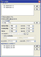
Point cloud data editor
- Point Cloud Data Plug-in's basic functions are to display 3D point cloud
data in UC-win/Road VR space and depict the point cloud data at the designated
position correctly. This plug-in can also extract data, import additional
data and adjust the display position by moving the points sideways or by
rotating them in VR space. In addition, this plug-in can also generate
TIN data (ground and seabed data) based on the point cloud data, and overlay
textures and import color from aerial photographs onto the point clouds.
This plug-in is also able to export terrain data produced using point clouds
in LandXML format to be used in other software systems.
As a post-processing function, this plug-in can extract road alignment
data and cross section data and use them in UC-win/Road to model roads
almost automatically.
 |
|
 |
Maximum number of point cloud data
- 32bit OS(Windows XP) : less than 16 million points
- 64bit OS(Windows Vista, Windows 7) : more than 25 million points
|
|
|
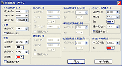
Main edit functions
- Point cloud display
- TIN terrain data generation
- Extraction of road alignment and cross section information
|
|
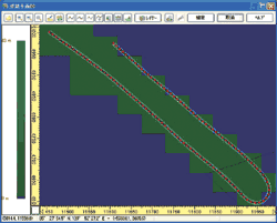
Extracting center lines
- Road center lines can be extracted using automatic search and manual assignment.
Automatic search utilizes the measurement feature of the mobile scanning
device (e.g. MMS: Mobile Mapping System) whereas manual assignment generates
continuous linear regression arbitrarily as the user selects point clouds
manually.
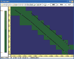
Editing road alignment
- The X (east-west) and Z (north-south) alignment data of the extracted center
line point clouds is linked to the road alignment editor in UC-win/Road
for road creation and editing.
 |
|
 |
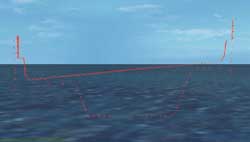
 Aerial view (point sequence) Aerial view (point sequence) |
|
Aerial view (road alignment) |
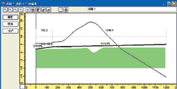
Road cross section editor
- The L (length) and Y (elevation) information is linked to the road cross
section editor in UC-win/Road to edit the vertical alignment of the road.
 |
|
 |
| Cross section (point sequence) |
|
Cross section (alignment) |
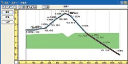
Extraction of road section point cloud data
- Road section information is extracted by automatically extracting point
cloud data from inside a large rectangular frame and generating point sequences
of the road section.
 |
|
 |
| Point sequence and the point cloud of the road section |
|
Point sequence of the road section |
Road section editor
- Point sequence of the road section is linked to the road section editor
in UC-win/Road to create and edit the road section.
 |
|
 |
| Point sequence and the road section |
|
Road section in 3D |
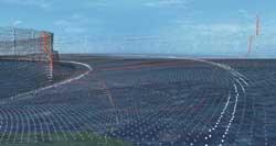
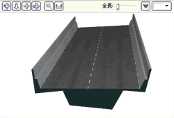
Road modeling
- Based on the road alignment data and the road section data that were generated
above, road modeling in UC-win/Road can now be carried out.
 |
|
 |
| Point cloud data only |
|
Road model |
|
| UC-win/Road Ver.5.0 point cloud data planned release date: August 2010 |
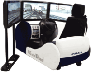
| UC-win/Road Ver.5.0 Safety Driving Simulator / Safety Driving educational
material |
Preface
|
This simulator is a driving simulator for driving schools, which is compatible
to the model certification standard of driving simulator by Japan Traffic
Management Technology Association.
Users can experience a real-car-like simulation by the simulator which
can reproduce hazardous events at the time of driving, wide view point
realized by the 42 inch 3CH monitor and the mounted steering system of
real car parts. After the drive experience, various kinds of diagnosis
is available accrding to the driving materials. Diagnosis is carried out
using the data collected during the above driving lessons. Data from all
the participants can be collected for calculation of aggregates and statistics.
We are now actively trying to clear the model certification standard. |
|
 |
Safety Driving Educational Material
- 6 kinds educational materials compatible to the model certification standard
and 2 optional education materials.
 Standard scenario compatible to model certification standard Standard scenario compatible to model certification standard
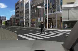
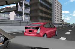
- Lesson on Hazard Perception
Hazardous events on the road are simulated on the driving simulator and
users can experience the events. Users can experience 13 hazardous events
including collision with a pedestrian, turning against traffic and pedestrian
rushing out from between parked cars while driving on the 5.5 km road.
 |
|
 |
|
 |
| Collision with a pedestrian |
|
Turning against traffic |
|
Pedestrian rushing out from between parked cars |
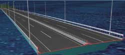
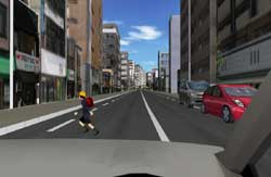
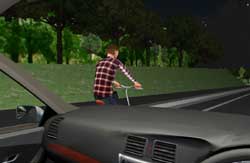
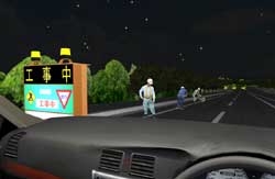
- Lesson on night-time driving
To acquire the knowledge and the skills for night-time driving, users can
experience driving on a 5.5 km city road with 9 hazards
 |
|
 |
| Overtaking a bicycle |
|
Lane restriction due to construction |
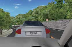
- Lesson on sudden braking
Users can experience 1.5km mountain road and braking distance on dry surface,
wet surface and frozen surface based on certification standard.
 |
|
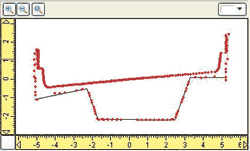
 Driving speed on wet surface Driving speed on wet surface
and the braking distance
| 100km -> 0km (kph) |
57.2m |
| 80km -> 0km (kph) |
37.1m |
| 60km -> 0km (kph) |
20.9m |
| 40km -> 0km (kph) |
9.5m |
| 20km -> 0km (kph) |
2.3m |
|
| Collision with a preceding vehicle |
|
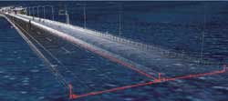
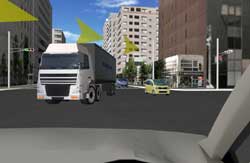
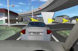
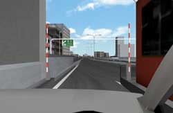
- Lesson on driving on the highway
Users can acquire the knowledge and the skills about driving on highways
by experiencing driving on a 20 km highway with more than 8 hazards including
collision with the tollgate and merging Traffic
 |
|
 |
| Collision with the tollgate |
|
Merging Traffic |
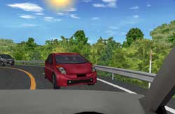
- Lesson on location-specific conditions
Users can drive along 8 km mountain road to learn about location-specific
conditions including different climate and geographical features including
speeding at a corner and collision with the car ahead.
 |
|
 |
| Speeding at a corner |
|
Collision with the car ahead |
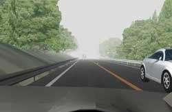
- Lesson on driving in bad condition
Users can experience the driving knowledge and skill by driving 5.2 km
length road featuring 5 sections with bad driving conditions such as fog,
rain and snow.
 |
|
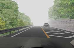 |
| Blizzard condition |
|
Dense fog |
Optional Scenarios
- Lesson on identifying violations
Examines the responses to cyclists rushing out, pedestrians and stopping
vehicles at an intersection
- Lesson on night-time visibility
Users can experience the breaking distance depending on the speed and the
color of the obstacles at the night-time driving with using headlights.
Diagnosis Data collection program function
- Results are produced from the data collected during the driving lessons
including driving operations and driving log. Driving log collects data
in terms of acceleration and breaking, smooth steering, driving at limited
speed, traffic signal, observing once atop, hazard prediction, safety and
ecological driving , headway (hazard prediction), clearance sense, considerate
driving, winker operation and seat belt.
Diagnosis result can be tabulated with graph and advice to the experience
driver.
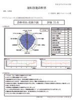 |
| Driving diagnosis |
|
UC-win/Road Ver.5.0 Safety Driving Simulator / Safety Driving educational
material planned release date: August 2010 |
|
| Conferences, training and seminars |
Up coming conference and trade shows
|
FORUM 8 will participate the following conference
ITE Show, August 8-11, 2011, Vancouver, Canada
ITE: Institute of Transportation Engineers
http://www.ite.org/annualmeeting/
Seminars in Shaghai, Beijing and Seoul will be held on the following schedule.
Venue:
Shanghai - Shanghai Seminar room (FORUM8 Technology Development(Shanghai)
Co., Ltd) MAP
Beijing- eMapgo Technologies(Beijing)Co.,Ltd URL
Seoul : FORUM8 Korean Office, Seoul Address
| Seminar |
Date |
City |
| UC-win/Road VR |
August 12th , 2010 |
Beijing |
| August 19th , 2010 |
Seoul |
| September 3rd, 2010 |
Seoul |
| September 14th, 2010 |
Shanghai |
| UC-win/Road Advanced |
August 4th , 2010 |
Shanghai /Seoul |
| September 9th, 2010 |
Seoul |
| September 16th, 2010 |
Beijing |
| UC-win/Road SDK |
August 11th , 2010 |
Seoul |
| September 8th, 2010 |
Shanghai |
Engineer's Studio(TM),
Engineer's Studio(TM)(2D)) |
September 17th, 2010 |
Seoul |
| VR-Studio(TM) |
September 28th, 2010 |
Shanghai |
| UC-1 Series Introduction |
August 27th , 2010 |
Seoul |
| xpswmm (Road for xpswmm) |
August 2nd , 2010 |
Seoul |
| OSCADY/TRANSYT |
August 18th, 2010 |
Seoul |
| Temporary sheating work design for Korean regulations |
September 24th, 2010 |
Seoul |
| Participation Fee |
| Participation Fee |
Free |
For more information and applications, please email us at:
mailto:forum8@forum8.co.jp
Gross circulation: 4174
To subscribe this page, go to http://www.forum8.co.jp/english/p-mail-e.htm
If you would like to unsubscribe from our newsletters, please include "Unsubscribe"
in the subject title of your email and send it back to us.
Thank you for your continued support.
FORUM8 Co., Ltd. mailto:forum8@forum8.co.jp
2-1-1 Nakameguro GT Tower 15F
Kamimeguro Meguro-ku Tokyo 153-0051 JAPAN
TEL +81-3-5773-1888
FAX +81-3-5720-5688
http://www.forum8.co.jp/english/index.html
|